Places to visit in uttaranchal -Beautiful abode of god

Uttaranchal The Land of God and Serenity
Uttaranchal is the 27th state of republic of India which was created on 9th Nov 2009.
Uttaranchal - the land of gods, the home of Himalayas and a paradise on earth, allures everyone from everywhere. The fresh air, the pure water, the chilling snow, beautiful mountains, the scenic beauty, the small villages, the simpler people and a tougher lifesytle is what that distinguishes Uttaranchal from rest of the world.
Uttaranchal is a paradise for mother Nature lover's and adventure sports enthusiasts.
It has some of the most beautiful hill stations to offer to nature’s lovers.
Mussoorie, the 'Queen of Hills'; Nainital, the 'Lake District'; Kausani, the 'Switzerland of India'; Ranikhet, Pithoragarh, Pauri and Munsyari are just few highlights for the nature lovers. For adventure and excitement, one may choose Mountaineering (Bhagirathi, Chowkhamba, Nanda Devi, Kamet, Pindari, Sahastrataal, Milam, Kafni, Khatling, Gaumukh), Trekking, Skiing (Auli, Dayara Bugyal, Munsyari, Mundali), Skating, Water Sports like rafting, boating and angling and Aero Sports like Hand Gliding, Paragliding (Pithoragarh, Jolly Grant, Pauri).
Also known as Dev Bhumi, Uttaranchal is a boon for the pilgrim tourists. The Maha Kumba Mela, the Char Dham Yatra and the Kailash Mansarovar Yatra give Uttaranchal an international recognisance. The major pilgrim places include Haridwar, Rishikesh, Kedarnath, Badrinath, Gangotri, Yamunotri, Devprayag, Nandadevi and Purnagiri.
The State is also a treasure house of exotic flora and fauna and is an ideal location for eco-tourism, as well as wildlife tourism. The world-famous JimCorbettNational Park is the pride of Uttaranchal. Other important sanctuaries are, RajajiNational Park, Govind Wildlife Sanctuary, Asan Barrage, Chilla etc.
Last but not the least, the rich cultural traditions and the cool and invigorating climate of Uttaranchal sums up for a perfect holiday destination to relax and unwind.
Famous Tourist Places In Uttaranchal
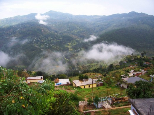
Mussoorie
Mussoorie, the queen of the hills, is one of the most popular and fascinating
hill resort of northern India.
Its green hills and varied fauna and flora make it a colourful and picturesque
hill station, commanding a wonderful view of extensive Himalayan snow ranges to
the North-East, and Panoramic view of the Doon
valley to the south. Mussoorie is also frequented by Honeymooners and is one of
the most popular honeymoon destinations in North India.
Places to visit in mussoorie
Gun Hill : During British Raj a Gun used to be fired from this hilltop to herald mid-day thus enabling people to adjust their watches. It had
therefore been named as Gun Hill, which is now connected by a Ropeway (400 m)
as well as a kilometre long bridle path leading from the Mall Road near Hakman's Hotel. The sheer
thrill of the Ropeways ride is memorable. Gun Hill offers beautiful panoramic view
of the Snowclad Himalayan ranges namely BandaI' Poonchh, Sri Kata, Pithwara and
Gangotri group etc. and and bird's eye view of Mussoorie town and Doon Valley,
particularly at night twinkling with lights as if the sky has come down on
earth.
Lal Tibba : Lal Tibba (2438.4 m) is the highest point of Mussoorie. There is a high power binocular kept here which provides a close and magnificent view of snow covered Gangotri, Kedarnath, Chaukhamba, Nanda Devi and Sri Kanta peaks.
Camel's Back Road: It starts from Kulri Bazar near Rink Hall and ends at Library Bazar covering a total distance of about 3 kms. The main charm of this froad is horse riding and wlking. Sunset view of the Himalayas is superb. Camel's Rock with a life like resemblace can be seen from the spot near MussooriePublic school.
Kempty Fall : 15 kms from Mussoorie on the Yamunotri Road having an altitude of 4500
ft. It has the distinction of being the biggest and prettiest waterfall located
in a beautiful valley and is surrounded by high mountains. Bath at the foot of the falls is refresshing
and enjoyable for children and adults alike.
Nag DevtaTemple:An ancient temple situated on Cart Mackenjie Road and is about 6 kms
from Mussoorie. Vehicles can go right up to the spot. It Provies a charming view
of DoonValley as well as of Mussoorie.
Mussoorie
Lake : A newly
developed picnic spot, situated on Mussoorie- Dehradun road and is about 6 kms
from Mussoorie. It is a delightful spot. Pedal boats are available. It commands
an enchanting view of DoonValley and nearby
villages.
Sir George Everest House : 6 kms The Park Estate of sir George
Everest, First Surveyor General of India, Who had his offce and
residence here, is approachable by road. The highest peak in the world, Mount Everest, is named after him.
Jwalaji
Temple (Benog
Hill) : 9 kms 6to the west of Mussoorie and at an altitude of 2104 mtrs.
Is the JwalajiTemple. It is situated on the top of the
Benog Hill and has an idol of Mata Durga in it. The temple is surrounded by
thick forests and offers a panoramic view of the Himalayan peaks, Doon valley and Yamuna valley.
Clous End : The bungalow built in 1838 by a British Major was one of
the First Four buildings of Mussoorie. The bungalow has since then been
converted into a hotel called Clouds End, and is situated at the extreme west
of Mussoorie Hill, 8 kms from Library. The resort is surrounded by thick
forest, offers a wide variety of flora and fauna besides a panoramic view of
snow clad Himalayas, and Yamuna river.
When to visit
The best seasons to visit Mussoorie is between April to June and again during September to November. When the plains of North India experience heat waves, Mussoorie provides a welcome break. September - November is springtime here. During this season Himalayas are clearly visible. It is better to avoid monsoons as the roads to Mussoorie are in bad shape. Same thing applies for the winter when roads are blocked due to snowfall
How to Reach Mussoorie
Air : Jolly Grant Airport Dehradun is the nearest Airport for reaching
Mussoorrie (24 kms). Air Deccan and Kingfisher Airlines operate daily flights
to Dehradun from New Delhi
Rail : Nearest Railhead is Dehradun (35 kms) which is directly connected with Delhi, Mumbai, Gorakhpur,
Kathgodam, Varanasi, Howrah, Rishikesh and Haridwar. Taxis are
available from Dehradun railway station to Mussoorie
Road : Mussoorie is connectd by regular bus
services to all the major centres of tourist interest in the region. Direct buses
are also available for some of the places as below
Barkot - 89 km
Srinagar Garhwal - 135 km
Hanuman Chatti- 129 km
Saharanpur- 110 km
Dehradun- 35 km
Nainital- 355 km
Tehri- 76 km
Delhi- 290 km
Mussorie
Click thumbnail to view full-size


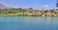
Nanital- Lake District of India
Nainital abounds in scenic natural beauty and its entire landscape is dotted
with lakes which has earned it the name 'Lake District' of India.
The most prominent of the lakes is Naini lake ringed by hills . Nainital has a varied topography .Nainital’s unending expense of scenic beauty is nothing short of a romance with awe-inspiring and pristine Mother nature.
Nainital, owing to its location, is colder than the rest of the hilly tract of Kumaon region. During monsoon, it gets heavy rainfall. The climate, therefore, is damp. The neighbouring areas of Almora and Ranikhet are warmer than Nainital. Similarly humidity in Nainital is less than in other hill towns. The monthly maximum and minimum temperature of the town ranged between 28.06 degree C and 7.06 degree C.
Places to visit in nanital
Naini Lake ( Nainital )-NainiLake or Naini Taal, the picturesque blue green lake is located in the district of Nainital.
It is from this lake that the city of Nainital, the beautiful settlement by the lake, derives its name. NainiLake is so called because of its eye-like shape.
Khurpatal
-At an altitude of (1635 MT) there lies just another beautiful spot at a
distance of 12 km from Nainital popularly known as Khurpatal. It is considered
to be anglers paradise having clear water and a good harvest of fishes.
Kilbury :- At about 12km. from Nainital at a height of (2528
MT) lies a place fit for weekend picnics.It is famous for its flora and fauna
and bird watching.One can have a wide panoramic view of Himalayas along with a
view of Tarai and Bhabhar.
China Peak /Naina Peak:- (2611 MT)-The highest peak of Nainital
provides a challenge to the most avid trekkers. Situated about 6 kms from the
town ChinaPeak
is known for its splendid Bird's eye view of the town, the Himalayas
and also the vast expanses of the Terai regions of Kumaon
Sat Tal ( SevenLakes) -On the way from Nainital to Bhimtal is a group of seven lakes called the Sattal. Nature has really provided this place beauty in abundance.
Bhimtal -The myth
goes that the lake was built during the Mahabharata era. You can get taxis and
buses at regular interval from Nainital. On the Nainital-Bhimtal road is MahraVillage.
Here through the efforts of Dr. Yashodhra Mathpal a rich collection of the
cultural and archeological items have been made. These artifacts from the
Uttrakhand region gives you an insight into the cultural heritage of this area.
At Bhimtal you can enjoy boating and have food at the restaurant on the island
in middle of the lake. Bhimtal is 23 kms from Nainital and there are good
accommodation facilities at the place.
Naina
DeviTemple
( Nainital )-The attractive lake of Nainital is said to be the eyes of
Sati, wife of Lord Shiva. Sati jumped into the sacrificial bonfire. Lord Shiva
to mourn the death of his beloved wife carried the body across the country. The
remains of her body fell at various places which today are sacred worship
places for the Hindus.
How to Reach Nainital
By Air : The nearest airport is at Pantnagar, which is 71 kms away. A coach
takes tourists to Nainital. Taxis and buses are also available.
By Rail : The nearest railhead is at Kathgodam, which is 35 kms away.
By Road: The city is well connected by a road network. All weather roads to Delhi (322 km), Bareilly
(141 km), Almora (66 km) and Ranikhet (60 km).
Public and private bus companies ply regular bus services between Nainital and Delhi, Lucknow, Bareilly, Hardwar, Dehradun, Almora, Ranikhet, Ramnagar and other important towns in the state.
Nanital
Click thumbnail to view full-size


Ranikhet (Queen's Meadow)
Ranikhet, as hill station, is idyllic in its charm, and draws holiday-makers almost all the year round with its salubrious climate and balmy breeze. Against the backdrop of snow-capped Himalayan peaks, Ranikhet means “Queen’s Meadow”.
At on altitude of 1829m, north of Nainital (61
km) and well connected to Almora (44km) & Kathgodam (83km), Ranikhet ( km)
has emerged as a favoured all season destination. During the rains, flowers
sprout up everywhere in rainbow colours, branches of trees stoop with ripened
fruits & sunlight peeping through the mist & clouds endow an enchanting
effect all across Ranikhet.
As winter comes, the softly falling snow flakes cover the environs in sheets of
pure whiteness.The 1869 the land was bought by British from local villagers and
a summer rest & recreation settlement was set for British troops. Today it
is an important army town and the headquarters of the Kumaon Regiment.
All the four seasons have something special to offer at Ranikhet. Therefore, it
can be visited at any time of the year. Winters are cold and the entire region
experiences snowfalls during the months of December and January.
Places to visit in ranikhet
Chaubatia Gardens: 10kms from Ranikhet are the
famous apple orchard which remain laden with fruits round the year. Ranikhet is
known for its delicious apples, apricots, peaches and various opther alpine
fruits. Besides apples, it is also possible to buy honey and fresh fruit juice
from the sales counter of the garden.
Jhoola Devi Temple- This secluded temple dedicated to Maa Durga has beautiful
bells, echoes of which can be heard from some distance. Nearby is a temple of Lord Rama.
Binsar Mahadev : 15 km from Ranikhet town is the BinsarMahadevTemple which has a beautiful stream flowing close to it. Apart from a Shiva temple, an ashram, Binsar Mahadev also has a lovely cedar forest surrounding it.
How to reach Ranikhet
Air : Nearest airport is Pant Nagar, (119km)
Rail : as with the other hill stations in the Kumaon Region, Kathgodam (83 km) and Ramnagar (96km) are the nearest railheads.
Road : Ranikhet is connected by road with all the major towns of the region.
There are regular buses to Almora, Nainital & Ramnagar operated by KMOU
& State Roadways, - 20643. It is also well connected to Delhi (279km), & Haridwar (254 km).
Beautiful Aerial View of Nanital City Courtsey Youtube
Ranikhet
Click thumbnail to view full-size


Scenic beauty of RANIKHET courtsey Youtube morsingh
Kausani
There are very few places in the Himalayas which can compare with the beauty of Kausani.As the entire Kumaon Hills have been known for their idyllic beauty with the huge mountains silhouetted against the sky.Kausani was originally called Valna. Kausani offers the magic of the deep pine forests and the majestic mountains. The close and captivating view which Kausani offers of the silvery majesty of the great Himalayas kindles hope even in the greatest pessimist and enlivens the worst of the depressed feelings. Several snow-capped peaks stand astride in a stately row over 300 kms in length shining against the pure blue of the sky making the Kausani horizon an enviable spectacle. This beautiful hill resort of Kausani is located in the Kumaon Region of Uttaranchal. Kausani stands high at an altitude of 1890 m above sea level.
Places to visit in Kausani
Baijnath : 17 kms from Kausani, the most important historical place in
Uttarakhand is Baijnath which is situated on the banks of the Gomti river. The Baijnath
temple here was built thousands of years ago and can still be admired for its
carvings and sculptures. Some old temples can also be found here.
Sundardoonga & Kafni Glaciers : For the more adventurous trekkers
these two glaciers are ideal. Both these glaciers are located in the Pindari
Glacier area in different spots. It is advisable to visit these places with an
experienced guide and proper equipment. Sundardoonga is known for its beautiful
rocks. One has to pass through Umla Jatoli village to go there. Dhakudi is a
camping point which is 35 kms away. To go to Kafni (3800 mts) one has to go
through a rough trek of 20 kms. from Dwali camp.
Lakshmi Ashram : 1 km away from the Anasakti Ashram, this place is a
center run by women who do social service. Gandhiji's disciple, Sarala Behen
spent her life here doing social service. This ashram is located in a solitary
area in a dense jungle.
Pindari Glacier : 25 kms from Bageshwar passing through Kapkot,
another 16 kms. later the last bus stop is Loharkhet. From here is a 35 km trek
to the famous Pindari glacier. To see this majestic glacier tourists camp on
the way to reach the Zero Point (3000 mts). From here is a close-up view of the
glacier. All though the way there are places to eat. A village called Khati
which is 18 kms after Loharkhet is one of the camping points. From Phurkia to
Zero point it is just 5 kms. The best time to visit here is April, May,
September and October. This glacier is 58 kms from Kausani.
How to reach Kausani
By Air : The airport nearest to Kausani is at Pantnagar, at a distance180 km.
By Rail : The railway station at Kathgodam is the nearest railhead to Kausani
at a distance of 142 km and caters to the rail transport to Kausani
By Road : Kausani is well connected with the other hill resorts like Almora,
Ranikhet, Pithoragarh, Gwaldam and Nainital through road route.
Kuasani
Click thumbnail to view full-size


Trekking to Pindari Glacier courtsey youtube-mngulati
Almora
Click thumbnail to view full-size


Almora
Of the three districts of Kumaon, Almora occupies a central location. Being further away from the plains than Nainital, this district provides tranquil spots where one can enjoy the mountain air without jostling against milling holiday-makers.
The town of Almora (1646 m), lies along a saddle-ridge amidst a lush amphitheatre of terraced slopes.Overlooking the arterial Mall, where the bus terminus, shops selling
bal mithai (a famous milk confection of Kumaon), and private lodges and restaurants are located, is flattish bowl-the virtual picture of fertility with its canals, hamlets and the foaming Kosi river.
"These mountains are associated with the best memories of our race: Here, therefore, must be one of centers, not merely of activity, but more of calmness of meditation, and of peace and I hope some one day to realize it." These were the words of Swami Vivekananda in the praise of almora where he spent some days of his life.
Almora is a good place to conveniently enjoy the spectacular
snowscape of the central Himalayas. On a clear
day - and most days in Almora are flawless - you can see forever and almost
every peak. Almora allows you to enjoy the mighty Himalayas
together with ridge after ridge of hills painted in different hues of blue and
green. The terraced fields, the stone slatted barrack-like village houses have
so far put up a valiant fight against the encroachments of urban expansion and
destructive development.
Places to visit in almora
Lakhuudiyar
Three very important protohistoric sites in the form of rock paintings have
been discovered near Almora. Twenty kilometres from Almora, near Barechhina
along the Almora - Pithoragarh route, on the banks of river Suyal, are to be
found paintings of human beings, animals, group of dancers, lizards, etc. in
the rock - shelter known as Lakhuudiyar. These paintings are said to belong to
the bronze - stone age. The place is very close to the road.
Phulseema and Pharkanauli
Similarly, in Pharkanauli and Phulseema (4 km) the rock - paintings belonging
to the protohistoric age can be seen. Here one finds an abundance of red lines
running in different directions and forming various dancing figures. Lately
more such rock - expressions and cup marks have been discovered. One must
stress at this point that any attempts by tourists to deface these valuable
masterpieces are absolutely reprehensible and unforgivable.
Binsar
Situated only 30 KMs away from the township
of Almora lies Binsar
nestled amongst thick forests of Oak and Rhodendron and yet offering
surprisingly close views of the Himalayan peaks. The entire region is now a
wildlife sanctuary and has a host of wildlife like Panther and Barking Deer.
The temple of Binsar lies nearby. One of the many
legends concerning Binsar states that 'Should anyone take away anything
belonging to the God or his worshippers and avenging spirit and compels him
conscience stricken to restore it twenty fold. Even the faithless and the
dishonest are said to be reformed by a visit to Binsar.
Bageshwer
Situated around 90 KMs from Almora, Bageswer is now a new district headquarter
and the centre of administration for the entire region called Danpur. The place
is significant from both religious and tourist point of view. Situated at the
confluence of the rivers Saryu and Gomti, Bageswer is the seat of the famous
Uttaraini fair which is held every year in January. The famous and ancient
temple of Bagnath from which the township gets it's name has been attracting
thousands of devout Hindus year after year since the birth of history. It is
believed that Markandey sage has lived at the place and that Lord Shiva, one of
the most important gods of Hindus had wandered about as a tiger. Even for the
adventurous tourist Bageshwer is a necessary destination since in order to
reach the glaciers of Sunderdunga, Kafni and Pindari one has to necessarily
cross Bageshwer.
Kalimutt
Situated around 4.5 kms from Almora, this picnic spot gives a lovely view of the HimalayanPeaks.
Jageshwar
Situated around34 kms away from Almora this temple of Shiva is situated amidst a dense Deodar forest and has a lot of mythological importance. Here there are about 164 temples of this kind.
How to reach Almora
By Air - The nearest airport is Pant Nagar (Nainital) which is 127 kms away from almora. Regular flights operate during the summer.
By Rail - The nearest railhead for Almora is Kathgodam which is 91kms away from almora.
By Road - Almora is well connected with all-important cities by road.
Best Season to Visit
Almora is situated at an altitude of 1,638 meters. The
climate in Almora can be described as moderate. The summers are warm in the
morning and pleasant in the evenings. The winters are cold and sunny during the
daytime while the nights are very cold with snowfall a couple of time during
the season.
The best season for tourist is during the months April-June and
September-November. one can have the view of the snow-capped mountains during
the early summers and autumns. The best time to witness snowfall is from the
end of December till the early February.
- Maha Kumbha- An event of a lifetime
One of the largest congregation on plant earth called Maha Kumbha which started on 14th Jan 2010 in Haridwar will end on April 28th 2010.So i thought of sharing some information with all my hub friends...


MORE HUBS OF THIS HUBBER
- Bottle Gourd-The Neglected Vegetable
When I was a kid mom used to tell me to have bottle gourd (Lauki) in my meal, but I never liked it until I had developed some heath problems. Then I realized the benefits of this neglected vegetable and... - Dancing Styles around the world
Different forms of dances are performed in different parts of the world. Origin of many of them is known to us while that of some still remains a puzzle. Not very sure if it will take a whole day or a month...

Related

My Journey to Bhimtal in the Himalayas and a Trip to My Ancestral Place in Misty Mountains

Ultimate Road Trip Itinerary for Exploring Northern Portugal from Lisbon
")
Visit of Holy Places in Madina Munawarra ( Ziarats)

Top Ten Places to Visit in El Salvador

Practical Advice for Those Visiting Mussoorie, India


